AEMET alerts
Orange weather alerts hit five regions as storms, hail and flash flood risk spread across Spain


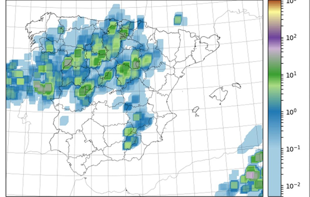
Storm cells spread across Spain as alerts remain in place today
Credit : X – Aemet
Large parts of Spain are facing a stormy Wednesday, with Madrid and four other regions under orange weather alerts as heavy rain, hail and strong wind threaten to disrupt travel, outdoor plans and the evening commute. Spain’s state weather agency AEMET has warned that some areas could see up to 30 litres of rain per square metre in just one hour, enough to trigger local flooding in a short space of time.
Ten autonomous communities are under some form of warning today, making this one of the most unsettled weather days of the week.
For residents, commuters and holidaymakers, the message is simple. Keep an eye on local forecasts, avoid unnecessary travel during severe storms, and be ready for sudden changes.
Which parts of Spain are under orange alert today
AEMET has issued orange alerts, meaning significant risk, for five regions:
Madrid
Aragón
Castilla La Mancha
Castilla y León
La Rioja
These are the areas expected to face the strongest storms today, with torrential downpours, hail and gusty winds possible.
In and around Madrid, the warning includes concern for the metropolitan area and parts of the Henares Corridor, where fast moving storms could cause difficult driving conditions and transport disruption.
Elsewhere, provinces including Soria, Zaragoza and Guadalajara are also among the areas most exposed to severe afternoon weather.
Yellow alerts also cover more regions
A further five communities are under yellow warnings, which still indicate potentially hazardous weather.
They include:
Andalucía
Extremadura
Galicia
Navarra
Basque Country
In these regions, AEMET warns that rainfall totals could exceed 15 litres per square metre in an hour, with isolated hail and strong gusts also possible.
That may sound lower than the orange alert zones, but summer style storms can be highly localised. One neighbourhood may see little rain, while another nearby is hit hard within minutes.
What weather to expect through the day
The first showers were expected to affect parts of western Spain, northern areas and inland regions early in the day. As temperatures rise, storms are forecast to build and spread across much of the country during the afternoon and evening.
Only some parts of the Mediterranean coast and the far northwest may avoid the worst of it. That pattern is typical of spring instability in Spain, where warm daytime air helps trigger sudden storm development later in the day.
For many people, the most disruptive period could be late afternoon, when roads are busy and people are travelling home or heading out.
Why hail and flash flooding matter
When AEMET warns of 30 litres in one hour, the issue is not just getting wet.
Heavy rain falling in a short burst can overwhelm drains, flood underpasses, create dangerous road spray and reduce visibility sharply. Hail can also cause problems for drivers, outdoor cafés, terraces, parked cars and pedestrians caught outside.
Strong wind gusts may bring down branches or send loose objects moving unexpectedly. Even a storm lasting 20 minutes can create travel chaos if it hits the wrong place at the wrong time.
Advice for Madrid residents and travellers
If you are in Madrid today, especially during the afternoon or evening:
- Check live weather updates before travelling
- Allow extra time for journeys
- Avoid parking under trees where possible
- Move terrace furniture or loose balcony items
- Delay outdoor sport if thunder is nearby
- Take care on roads as visibility may drop quickly
Public transport may continue normally, but delays are always possible during heavy storms.
Will the weather improve tomorrow
There is better news for Thursday, April 30. Forecasts suggest storms should weaken across much of Spain, with a more settled picture returning in many areas.
Some heavier showers could still affect the Ebro valley early in the day, while rain later shifts toward Galicia and the Cantabrian coast.
Elsewhere, any showers are expected to be lighter and more focused on mountains, the Pyrenees and inland parts of Catalonia. So Thursday may offer a useful break after today’s disruption. But Friday could turn stormy again
The calmer spell may not last long. Current forecasts indicate instability could increase again on Friday afternoon, especially in central and eastern Spain. Areas near the Iberian System and the Pyrenees may see storms redevelop.
That means anyone planning weekend travel should continue checking updated forecasts rather than assuming the worst has passed.
Why Spain’s weather has become so changeable
Spring often brings sharp contrasts in Spain. Warm sunshine can quickly be followed by heavy storms when cooler air higher up meets rising heat near the surface. That creates the kind of sudden downpours many residents know well.
Blue skies at lunchtime do not always guarantee a dry evening.
The key message today
Spain is not facing a nationwide washout, but many areas are at risk of intense local storms. If you live in or are travelling through Madrid, Aragón, Castilla La Mancha, Castilla y León or La Rioja, take the orange warnings seriously.
Storms may pass quickly. But while they are overhead, they can be powerful.