archaeologists
18th-Century Spanish warship wreck identified off coast in San Pedro


Underwater archaeologists in Andalucia have successfully linked a historic shipwreck off the coast of San Pedro de Alcantara to the Fernando, a Spanish Royal Navy ship of the line that sank during a violent storm in 1760.
Experts from the Centre for Underwater Archaeology, a branch of the Andalucian Institute of Historical Heritage (IAPH), led the investigation, which provides a major breakthrough for Spanish maritime history. Initial theories suggested the remains belonged to French vessels lost in 1705 during the Battle of Punta Cabrita, but new structural and archival evidence points directly to the ill-fated Spanish vessel.
Crucial clues on the sea bed
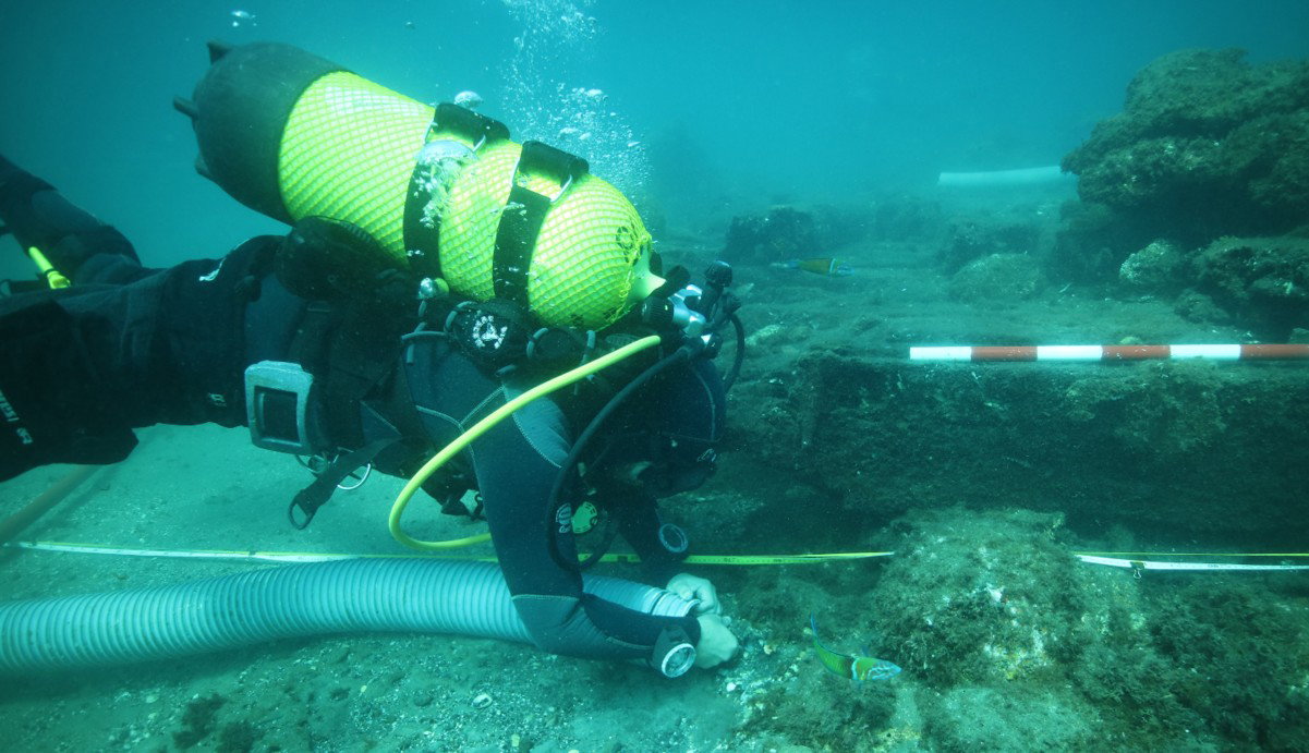
Resting at a shallow depth near the incredible, Placer de las Bovedas reef, the 65-metre-long wreck has exposed critical clues regarding its true identity. Heavy coastal currents shifting the seabed sediment, exposed a robust timber framework with high-density frames and distinct iron fastenings characteristic of 18th-century Spanish shipbuilding.
Divers focusing on the stern section located the post as well as iron components belonging to the rudder. Historical logbooks note that the Fernando suffered severe steering failure during a gale just before running aground, validating the physical damage found on site. Heavy artillery pieces scattered around the site also pre-date the Spanish Artillery Regulations of 1765, neatly matching the timeline of the 1760 disaster.
British design techniques
Construction records show that the Fernando was built at the Esteiro shipyard in Ferrol between 1750 and 1751. King Ferdinand VI, along with the Marquis of Ensenada and scientist Jorge Juan, commissioned the vessel as part of an ambitious programme to modernise the Spanish fleet by incorporating advanced British design techniques.
Gun ports measuring 1.10 metres wide by 0.85 metres high confirm the vessel was a heavily armed warship designed for major naval combat. Additional structural supports, including angled hull braces, mirror the British-influenced architectural blueprints used during this experimental phase of Bourbon naval engineering.
Creating a 3-D blueprint
Marine tech teams captured more than 3,000 underwater photographs to build a highly detailed three-dimensional model and orthophotograph of the entire site. This digital map helps researchers track the orientation of the debris field, plan targeted excavation trenches, and monitor structural erosion caused by winter storms and human activity.
Future phases of the project will involve dendroarchaeological and isotopic testing of the wood. Analysing these timber samples will help scientists determine the exact tree species used, the felling dates, and the geographical origin of the timber used in Ferrol. Local institutions, including the Spanish Navy, the University of Malaga, and the Marbella City Council, continue to support the ongoing preservation effort.