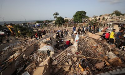
UPDATED – Friday July 10th
As of Friday morning, several fires stabilised overnight while others have forced evacuations and even caused deaths.
Spain’s state weather agency Aemet states that “the fire danger remains at very high or extreme levels in much of the country. Take extra precautions.”
This comes as news emerged overnight that a wildfire ripped through a hamlet in southern Spain and killed 12 people.
Initial reports suggest that four of the victims were British nationals.
Some of the dead in Bedar in Almería province were found in vehicles, the regional government said in a statement, revising an earlier toll of six dead.
Around 150 firefighters backed by five fire trucks battled the blaze which broke out as temperatures neared 40C. Authorities raised the death toll to 12 “after the confirmation of six more deaths in the area of the fire,” the regional government of Andalusia said in a statement.
Also in Andalusia, a thousand people were evacuated as a precautionary measure due to the wildfire that broke out on Thursday afternoon in Benahavís, Málaga province.
However local media reports on Friday morning that emergency services have allowed locals to begin returning to their homes and that the AP-7 motorway has reopened.
In Catalonia, local media reports that emergency services have brought the blaze in Les Gavarres under control and managed to stabilise those in Sentmenat, Aiguamúrcia (Tarragona), Navarcles (Bages) and Gavà.
Meanwhile large areas of Aragón remain on high alert following the regional government issuing a red-level alert on Thursday afternoon.
The authorities have implemented the highest level – Alerta Rojo Plus – for six municipalities due to extreme fire risk on Friday.
The measure will be in effect throughout the day on Friday, July 10th, in: Hoya de Huesca, Somontano de Barbastro, Cinca Medio, La Litera, Los Monegros, and Bajo Cinca.
🔴🔥 El Gobierno de Aragón declara la Alerta Rojo Plus para mañana en seis comarcas por riesgo extremo de incendios.
🚫 La medida estará vigente durante toda la jornada del viernes 10 de julio en la Hoya de Huesca, Somontano de Barbastro, Cinca Medio, La Litera, Los Monegros y… pic.twitter.com/K6t9UfUkmf
— Gobierno de Aragón (@GobAragon) July 9, 2026
In Castilla-La Mancha firefighters were working to extinguish the forest fire that broke out in the Las Pinillas area, within the municipality of La Guardia (Toledo), which has already burnt some 500 hectares.
This year’s fire season started early in Spain with blazes in Castellón province forcing the evacuation of locals.
Nearby, the Catalonia government recently lifted a lockdown that confined 12,000 residents to their homes as firefighters managed to contain the blaze that broke out in La Bisbal d’Emporda, 12 miles from the popular Costa Brava coastline.
Where are the wildfires in Spain?
These fires can be particularly scary if you live in the nearby areas or if you find yourself travelling through an area that has been ablaze or covered in dark smoke.
Thankfully, there are several ways to find out where the active wildfires are, how intense they are, how big they are and the current status of each.
It’s worth noting also that many Spanish media outlets also post updated fire maps, such as this Europa Press map available here that allows you to search by municipality.
If you want to know about past fires, you can also look at this map from Civio which shows all the wildfires in Spain between 1968 and 2017 that burned one hectare or more.
Google Maps
Google combines public data with satellite imagery and automated models to provide wildfire information, which is frequently updated.
The Google Maps app is accessible from both iOS and Android. You can also find it on your desktop browser at maps.google.com. Here you’ll find a layer specifically dedicated to wildfires.
To find it, simply open Google Maps and tap the layers icon. On a computer, it’s located in the lower right corner. Once it appears it will shift to the left and you’ll click on ‘Layers’. From here, click on more and then on the ‘Wildfires’ icon.
On a mobile device, it appears on the home screen. From the menu, select ‘More’ or ‘Crisis Layers’. then activate the ‘Wildfires’ layer like before.
You need to zoom into a particular area to be able to see them.
READ ALSO: What to do and what to avoid if you see a wildfire in Spain
Once activated, the map shows real-time data such as satellite-detected hotspots, estimated fire perimeters, and impacted areas. SOS icons include emergency phone numbers, links to civil protection, and evacuation alerts.
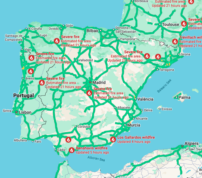
There are various active wildfires in Spain on Friday July 9th. Photo: Google Maps.
Incendios Forestales en España en Tiempo Real
The Incendios Forestales en España en Tiempo Real page uses various sources including NASA satellites and local fire emergency service information to track forest fires.
It combines data on active wildfires in Spain and automatically updates every 5 minutes.
The interactive map lets you search on a regional level and groups individual fires into single heat points, which are colour-coded by severity.
This map combines data on active wildfires in Spain from four complementary sources, which are automatically updated every 5 minutes.
As of 09:00 on Friday morning, the map showed 151 different satellite points.
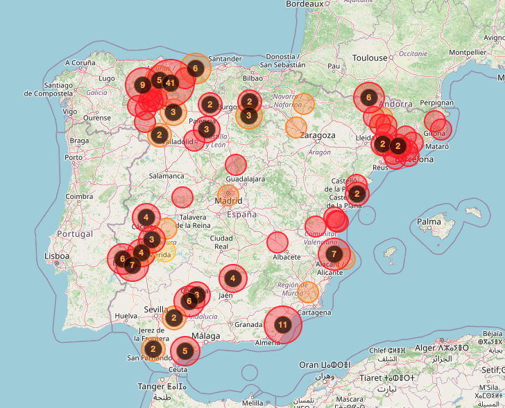
Photo: Incendiosespana.es
Wildfire alert levels
Similarly, for an overall picture of the risk level, Spain’s state weather agency, Aemet, provides risk maps, available here and below, that show danger levels for risk of forest fires and wildfires.
The forest fire weather danger level, which Aemet issues daily, is based on the FWI index from the Canadian system (calculated using data from Aemet’s weather stations and prediction model) combined with non-meteorological variables such as land and vegetation conditions, forest land use and soil moisture.
As per Aemet’s danger level system: “Fire danger is categorised into six classes or danger levels (very low, low, moderate, high, very high and extreme), which serve as indicators of the probability of a fire occurring, as well as its extent and intensity.”
On Friday morning, large areas of eastern, western and southern Spain are on red-level (extreme risk) with lots of inland Spain still on orange-level alert (very high).
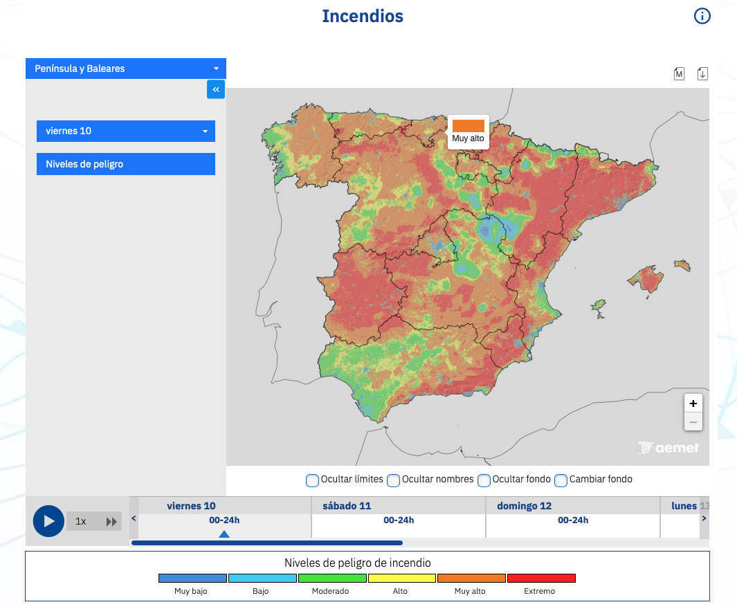
Wildfire risk levels. Photo: Aemet.
With additional reporting from AFP.






 TWO beer lorries have been stolen from an Estrella Damm depot in Mallorca. The thefts were discovered early on Friday morning with the Policia Nacional in Palma in charge of