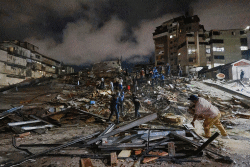
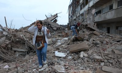
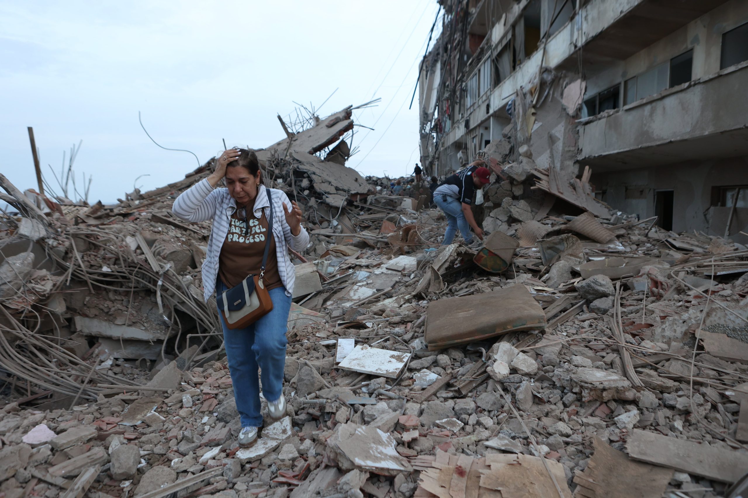
Two powerful earthquakes less than 40 seconds apart struck Venezuela, causing widespread destruction and killing more than 160 people on Wednesday. The U.S. Geological Survey (USGS) estimates that the final death toll could reach into the tens of thousands. The agency also warns that aftershocks are almost certain, with nearly a 30% probability that they could exceed magnitude 6 on the Richter scale.
Its automated hazard assessment system has flagged potential landslides and liquefaction — a phenomenon that can cause buildings to sink into the ground, as has occurred in earthquakes in Japan. The USGS estimates a 42% probability that the death toll could range between 10,000 and 100,000, with economic losses of between $10 billion and $100 billion.
Venezuela is a high seismic-risk zone. It lies near the boundary between the Caribbean and South American tectonic plates, which move in nearly opposite directions, building up seismic tension. The two earthquakes occurred along the Boconó fault, one of the most active and dangerous in the country. At present, around 80% of the population lives in areas of high seismic hazard, a factor that increases overall risk — intensifying as population density rises and infrastructure investment expands — according to the Venezuelan Foundation for Seismological Research.
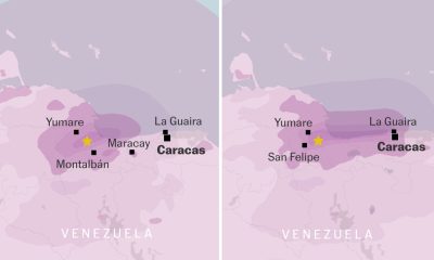
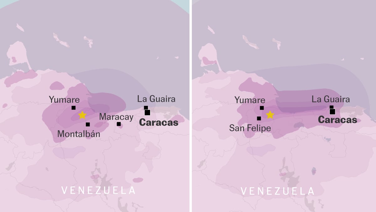
The first foreshock measured magnitude 7.2 and struck at a depth of 12.4 miles. Just 39 seconds later, a second, larger quake of magnitude 7.5 hit at a depth of 6.2 miles. Both tremors occurred southeast of Yumare, in northwestern Venezuela.
Northern Venezuela has a history of large, destructive earthquakes. However, within a 155-mile radius of this Wednesday’s twin quake — recorded at 6 p.m. local time — only seven earthquakes of magnitude 6 or higher had been recorded over the past century.
The region recently experienced another doublet in September 2025, consisting of a magnitude 6.2 earthquake followed by a 6.3 event to the west-southwest of the most recent tremors. That 2025 sequence caused at least one fatality, more than 110 injuries, and extensive structural damage in the states of Zulia and Lara.
In September 2009, a magnitude 6.4 earthquake east-northeast of Morón injured 18 people and damaged buildings, and a magnitude 6 event in 1989 caused light damage in the Valencia area. Further west, a magnitude 6.1 quake shook the region in April 1975.
The most devastating modern earthquake in the vicinity was the July 1967 Caracas quake (magnitude 6.6), with an epicentre about 81 miles to the east. It caused roughly 240 deaths, hundreds of injuries, and led to the collapse of multiple high-rise residential buildings and widespread destruction. In a broader Venezuelan context, there have been five earthquakes of magnitude 7 or greater in the country’s north or near the coast since 1900.
In 1812, during Venezuela’s fight for independence from Spain, another devastating earthquake originating on the Boconó fault struck the country, causing some 30,000 deaths, according to the United States Geological Survey.
“Not only was the energy high, but the quakes were also very shallow, especially the second, which is devastating,” says Miguel Ángel Rodríguez Pascua, director of the Geological Hazards Department at the Geological and Mining Institute (IGME-CSIC). “Venezuela’s tectonic situation is dominated by the boundary between the Caribbean plate and the South American plate, an active contact that creates a roughly 100-kilometre-wide [62-mile] seismic belt where most of the country’s earthquakes are concentrated.”
IGME geologist Raúl Pérez notes: “This type of earthquake is not common in this configuration, and worse, they are tremendously damaging.”
The two quakes were so close together that people felt them as a single long earthquake.
“Normally, when one quake is followed by a second, the epicentres are separated by hundreds of kilometres, which spreads out the damage,” he says. “In this case, the area of greatest intensity overlaps. And on top of that, they occurred right at the confluence of two faults, the San Sebastián and Boconó faults, which have high tectonic slip rates and a huge capacity to store energy. Bear in mind that this confluence had not been active since 1900, so it had been building up tectonic energy for 100 years that was released in these two quakes that happened, let’s say, one on top of the other.”
The Boconó fault runs for about 310 miles through the Andes mountain range. Numerous faults converge with or diverge from its main axis. It extends across western Venezuela in a southwest direction between the town of San Cristóbal, near the Colombian border, and Morón on the Caribbean coast of Golfo Triste.
Pablo Silva, chair of Geological Hazards at the University of Salamanca, explains that the Boconó fault passes through the middle of Caracas, a city of about three million people with many high-rise buildings. “Automatic casualty estimates are made based on population and using the capital’s building types as a baseline, but those building types are actually very different in the rural areas also hit by the quake, which could significantly raise the final casualty count,” he says.
The seismologist explains that although a doublet like this Wednesday’s was “to be expected,” “you are never prepared for something like this.” On the possibility of preventing earthquake impacts, he says there is only one sure method: enact and enforce seismic-resistant building standards. He points to the 2010 Haiti earthquake, magnitude 7.2, which caused about 300,000 deaths because of the poor state of buildings. By contrast, he says, a similar quake years later in San Francisco, where structures are earthquake-resistant, caused negligible fatalities.
Sign up for our weekly newsletter to get more English-language news coverage from EL PAÍS USA Edition
 SPAIN has pledged emergency assistance to Venezuela after two powerful earthquakes struck the country, killing at least 32 people. Jose Manuel Albares, Spain’s Foreign Minister, has expressed solidarity with Venezuela


 America2 weeks ago
 Uncategorized2 weeks ago