Connect with us

aemet

Canarias Se Suma Al Aviso Rojo Por ‘Bruna’ Y ‘Charles’, Que Persiste En Extremadura Y Castilla Y León

Published

on

canarias-se-suma-al-aviso-rojo-por-‘bruna’-y-‘charles’,-que-persiste-en-extremadura-y-castilla-y-leon

Los borrascas Bruna y Charles no se suman a la huelga general de este miércoles. Muy al contrario, han unido sus fuerzas para azotar a España con el “día más adverso” del temporal de lluvias persistentes y abundantes, fuertes vientos y mala mar que comenzó el sábado y que aún durará hasta el jueves. Entre las dos, han llenado de avisos el mapa de la Agencia Estatal de Meteorología (Aemet), que los ha decretado en 11 comunidades más Ceuta, con tres avisos rojos, el máximo, en Canarias, Extremadura y Castilla y León. A primera hora eran 14 comunidades, pero ya se han levantado los avisos de Navarra, País Vasco y La Rioja. Hasta las 11.00, ya se han medido rachas de viento huracanadas de 134 kilómetros por hora en Izaña (Tenerife), 122 en Tejeda (Gran Canaria) y 117 en el aeropuerto de La Palma y, en cuanto a la lluvia, se han recogido 41 litros por metro cuadrado en La Palma, 40 en Aliseda (Cáceres) y 39 en Guadalcanal (Sevilla). Hasta las 22.00 del martes, Bruna ya había dejado 225 litros en Puerto el Pico (Ávila), 193 en Garanta la Olla (Cáceres) y 191 en La Zarza (Ávila).

Para empezar, Castilla y León y Extremadura siguen, por segundo día consecutivo y durante toda la jornada, bajo aviso rojo, que implica peligro extremo para la vida, las infraestructuras y los bienes, por lluvias muy fuertes y persistentes, a las que se suma Canarias, también en rojo hasta el mediodía, pero por vientos huracanados de más de 120 kilómetros por hora en la isla de La Palma. El archipiélago tiene además avisos naranjas por viento ―segundo escalón de un sistema de tres― en el resto de islas, y naranjas y amarillos ―el mínimo― por mala mar y lluvias. Por su parte, el nivel de riesgo por viento es naranja en el caso de Extremadura y amarillo en el caso de Castilla y León.

⚠️ El paso de la borrasca Charles dará lugar a tiempo muy adverso en la jornada del miércoles en Canarias y amplias zonas de la Península.

📺 Video con más información 👉 pic.twitter.com/JoPBM0BKxc

— AEMET (@AEMET_Esp) November 10, 2026

Además, Andalucía está en naranja por todo (lluvia, viento, tormentas y mala mar); Castilla-La Mancha y Ceuta, naranja por viento y amarillo por lluvia; Aragón y Comunidad de Madrid, amarillo por lluvia y viento; Cataluña, Galicia, amarillo por lluvia; y Murcia y Comunidad Valenciana, amarillo solo por viento. La Aemet ha retirado los avisos de anoche en Navarra, País Vasco y La Rioja.

La causa de semejante mapa, explica a Aemet en su aviso especial, es el “desplazamiento de Charles ―una pequeña pero profunda borrasca de origen subtropical― hacia la Península, penetrando por el suroeste peninsular”. Este sistema de bajas presiones “llega con mucha, mucha energía y sus efectos serán muy adversos”, advierte el portavoz de la Aemet, Rubén del Campo, en un vídeo, que habla de “inundaciones locales, crecidas de ríos y barrancos y deslizamientos de tierra”, así como el derrivo de ramas, árboles y elementos que puedan salir volando.

🔴 Avisos rojos (peligro extraordinario)

🌧️ Norte de Cáceres y sur de Ávila: lluvias muy abundantes (más de 120 l/m² en 12 horas) el martes y miércoles. Inundaciones y crecidas.

🌬️ La Palma: vientos huracanados el miércoles (más de 130 km/h). Caída de ramas y otros objetos.
1/2 pic.twitter.com/odZX8oY9L5

— AEMET (@AEMET_Esp) November 10, 2026

Ya de madrugada, el paso de Charles por Canarias producirá “un incremento muy significativo del viento, dejando rachas de 130 kilómetros por hora en La Palma y de 100 a 120 en las cumbres y zonas expuestas”, así como un empeoramiento del estado de la mar, con olas de más de seis metros. Además, habrá lluvias fuertes, a veces con tormenta, que podrían ser muy fuertes en La Palma, donde más lloverá.

A mediodía y primeras horas de la tarde, la peor cara del temporal se habrá trasladando ya a la Península, donde “se producirán precipitaciones generalizadas, localmente acompañadas de tormenta, que serán menos abundantes cuanto más hacia el noreste, salvo puntos de Pirineos”. Se espera recoger en general más de 40 a 60 litros por metro cuadrado en amplias zonas del oeste, sur y centro peninsular y, más concretamente, 80 en las sierras del noroeste de Andalucía, sierra Nevada, Grazalema, Ronda, Sol y Guadalhorce. En el Sistema Central, más de 120 en 12 horas.

Arrecirá el viento, “con rachas muy fuertes en amplias zonas de la Península”, más intensas en el cuadrante suroeste peninsular, donde es posible que se alcancen los 100-120 kilómetros por hora, no solo en zonas montañosas, sino también en áreas bajas del sur de Castilla y León, Extremadura, oeste de la meseta sur y de Andalucía. También se pueden producir tornados y mangas marinas en el golfo de Cádiz.

⚠️ ACTUALIZACIÓN AVISO ESPECIAL | Lluvias fuertes y persistentes, rachas de viento muy fuertes y temporal marítimo.

➡️ Miércoles muy adverso en el oeste y sur de la Península y
en Canarias por el paso de la borrasca Charles. ¡Precaución!

+ info 👉https://t.co/48Lsr8QC4f pic.twitter.com/Cq4ir1Bqzk

— AEMET (@AEMET_Esp) November 10, 2026

Por la tarde, el vendaval también se intensificará en el interior este peninsular y en Pirineos, con rachas de 70 a 80 kilómetros por hora. El temporal marítimo irá a más en el golfo de Cádiz, con olas que pueden superar incluso los seis metros.

Un día más, la Aemet admite que todavía se desconoce con exactitud la posición final de la borrasca Charles, por lo que cualquier cambio en su trayectoria puede desplazar las máximas de precipitación y de viento a puntos imprevistos.

La agencia confía en que, a partir del jueves, a medida que Charles se despida y emprenda viaje hacia el noreste, el viento vaya amainando y se vaya aflojando también la intensidad de las lluvias y el área afectada. “Aún podrían registrarse chubascos localmente fuertes y persistentes en puntos del tercio norte, especialmente en Pirineos, norte del sistema Ibérico, Galicia y área cantábrica”, señala la Aemet en su aviso.

En cuanto al viento, “las rachas todavía podrán superar los 100 kilómetros por hora en el sistema Central y sistema Ibérico de madrugada, y los 70-80 en puntos del interior este, Pirineos y Baleares”. Por último, el temporal costero “se irá trasladando de sur a norte por el Mediterráneo, con viento fuerte y olas de dos a tres metros”.

aemet

November weather shift: Rain and chillier air head towards eastern Spain

Published

on

By

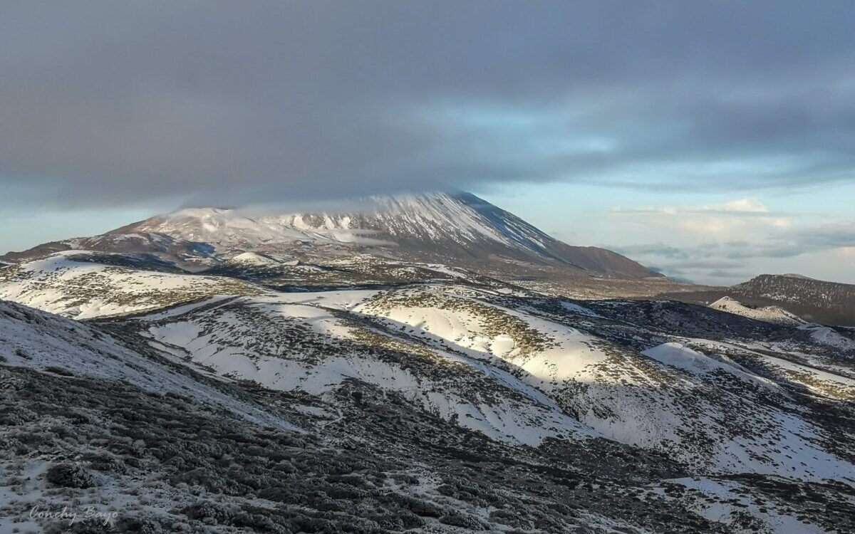
Mt. Teide in Tenerife sees snow.
Credit: ConchyBayo X

Rain is expected to spread along the Mediterranean coast from Tuesday, November 3, while temperatures begin to fall and snow becomes possible in northern mountain ranges.

People living in parts of eastern and southern Spain could be reaching for their umbrellas this week as a change in the weather brings more unsettled conditions from Tuesday, November 3, so make hay while the sun shines.

Monday, November 2, should be relatively pleasant across much of the mainland, with sunshine and mild temperatures. However, cloud and showers are expected to increase along the Mediterranean coast as the week progresses, with some areas will face locally heavy rain, especially in the north of Mallorca.

The change will be accompanied by a noticeable drop in daytime temperatures in several parts of the country, although southern coastal areas should avoid the sharpest chill.

Monday, November 2: Mostly sunny but showers on horizon

The working week should get off to a largely dry and sunny start in Malaga, Granada, Almeria and much of the Valencian Community. Forecast highs include around 22ºC in Malaga, 23ºC in Granada and 25ºC in Almeria. Murcia could reach 23ºC, while Alicante and Valencia are expected to see temperatures of approximately 22ºC.

There is a greater chance of afternoon showers around the Murcia region, while cloud is likely to increase along parts of the Mediterranean coast.

Tuesday, November 3: Rain moves across the Mediterranean

Tuesday looks set to bring the biggest change for people living along Spain’s eastern seaboard. Showers are forecast in parts of the Valencian Community, Alicante, Murcia and Almeria, with rain also possible around Malaga. The Denia area could see particularly unsettled conditions during the morning, while showers are expected in Alicante and Murcia at different points during the day.

Granada is expected to have a largely dry day, although cloud will increase and temperatures should be a little lower than on Monday. Daytime highs are forecast to reach around 22ºC in Malaga, 20ºC in Granada and Alicante, 23ºC in Almeria and 24ºC in Murcia. Valencia could struggle to get much above 19ºC, while Palma is expected to only reach around 18ºC.

Mallorca may also see showers, although the latest AEMET forecast does not currently confirm the yellow rain warning previously suggested. Residents and visitors can check the official AEMET weather warnings for any changes.

Wednesday, November 4: More unsettled weather and mountain snow

The unsettled conditions are expected to continue on Wednesday, particularly along the Mediterranean coast. Malaga and Almeria could see showers through much of the day, while Granada is forecast to have a cloudier afternoon with a chance of rain. Murcia may see showers during the morning before conditions gradually improve.

Valencia could also have some early rain, although the afternoon is expected to be largely cloudy rather than persistently wet. Alicante looks set to have a better day, with brighter spells and a much lower chance of rain. Mallorca may see the odd passing shower, but brighter intervals are also forecast.

Temperatures are expected to fall further in some areas, with highs of around 21ºC in Malaga and Almeria, 19ºC in Granada, Alicante and Valencia, and 20ºC in Murcia. Palma could climb back to around 21ºC.

Snow expected in northern mountains as temperatures fall

The change in weather will be more noticeable across parts of northern and north-eastern Spain. Snow is forecast in some of the higher mountain areas, particularly the Pyrenees, while the Picos de Europa and parts of the Iberian mountain system could also see wintry conditions.

Snow levels in the Pyrenees are expected to fall to around 1,300 to 1,600 metres in places, a good omen for the upcoming ski season. Frost is also possible at higher elevations across the northern half of the mainland. However, snow-capped peaks usually indicated a temperature drop for everyone.

Tenerife rain alert as snow appears on Mount Teide

The Canary Islands are also facing unsettled weather, with Tenerife under a rain alert in its metropolitan area and pre-alert status elsewhere on the island.

The Canary Islands Government said locally heavy showers could continue on Monday, November 2, particularly during the first part of the day, with the unsettled conditions potentially lasting into the early hours of Tuesday. Residents and visitors have been advised to follow updates as the situation develops.

Higher up, Mount Teide is already seeing a wintry change. AEMET forecasts the snow level falling towards 2,700 metres on Tuesday, bringing the possibility of snowfall on the island’s highest ground.

For much of Malaga, Granada and Almeria, daytime temperatures should still be relatively mild, even as cooler nights and more unsettled weather arrive.

The overall picture for November 2 to 4 is therefore one of changing conditions: a largely sunny Monday, a wetter Tuesday across parts of the east, and further showers on Wednesday, with the sharpest temperature changes expected further north.

Forecasts and weather warnings can change, so residents should check the latest updates from AEMET before travelling or making plans.

Continue Reading

aemet

El Tiempo Del Puente De Todos Los Santos: Sol Y Temperaturas Altas Para La época

Published

on

el-tiempo-del-puente-de-todos-los-santos:-sol-y-temperaturas-altas-para-la-epoca

El tiempo que se espera para este puente de Todos los Santos en España se resume en una palabra: soleado. Así, habrá un predominio de la estabilidad en la mayor parte de la Península y tan solo se esperan chubascos, que pueden ser localmente fuertes y acompañados de tormentas, en el área mediterránea, Baleares y Canarias, según pronostica la Agencia Estatal de Meteorología (Aemet). Las temperaturas máximas seguirán por encima de lo normal para esta época, aunque por fin comenzarán a bajar, una tendencia que se acentuará la semana que viene. Esta calma chica se refleja fielmente en los avisos: este viernes y el sábado, tan solo hay dos: amarillo, el mínimo, por lluvias en Baleares y niebla en Galicia. El domingo, por el momento, no hay ninguno.

Seguir leyendo

Continue Reading

%

Weather Watch: Heavy Rain Threatens Canaries

Published

on

weather-watch:-heavy-rain-threatens-canaries

Teide to get soaking. Credit: Ralf Geithe Euro Weekly News

Spain is heading into Halloween weekend with contrasting weather conditions, as much of the mainland enjoys settled skies while the Canary Islands prepare for potentially heavy rain. The country has recently enjoyed a spell of unusually warm weather, but conditions are set to vary considerably between regions.

Meteorologist José Miguel Viñas has warned that three Canary Islands could receive more than 50 litres of rain per square metre over the coming days, with showers and thunderstorms expected to develop as a new weather system approaches.

Three Canary Islands face heavy rain

Tenerife, La Palma and El Hierro are the islands to watch, with the developing system potentially bringing substantial rainfall from Saturday, October 31, into the beginning of next week.

The forecast points to increasingly unsettled conditions, with the possibility of locally heavy showers and thunderstorms. A pocket of cold air high in the atmosphere is expected to help trigger the change. Similar weather concerns have recently featured in EWN’s coverage of heavy rain and storms threatening Spain’s Mediterranean coast.

Rainfall of 50mm or more could cause problems in vulnerable locations, particularly where water drains poorly. Residents and holidaymakers should follow local forecasts, especially if planning mountain walks or road journeys. The official weather alerts from the Canary Islands Government provide an additional source of information about declared emergency alerts.

Forecasts can change, however, and the predicted rainfall totals do not mean every part of the three islands will receive the same amount.

Mainland Spain enjoys a warmer Halloween

Conditions across much of mainland Spain are expected to be considerably calmer on Friday, October 30, as high pressure keeps skies largely clear.

Andalucia is set to enjoy some of the warmest temperatures, with Seville forecast to reach 29ºC, while Granada and Huelva could see highs of 27ºC. Madrid is expected to reach around 22ºC.

Rain is more likely along parts of the Mediterranean coast, particularly in Catalonia and the Valencian Community, where isolated showers are possible, making All Saint’s traditions a little wet.

The Balearic Islands face a greater risk of unsettled weather, with showers potentially becoming locally heavy and accompanied by thunderstorms around the middle of Friday.

Strong winds and a warning for travellers

Drivers and residents around the Strait of Gibraltar should also watch for strong easterly winds, with particularly powerful gusts possible during the early hours. Morning mist and fog could affect parts of Galicia and the Cantabrian coast, potentially reducing visibility on the roads.

Although much of the country looks set for a pleasant end to October, conditions will vary considerably between regions.

Residents should check AEMET’s latest weather forecasts and official warnings before travelling or spending time outdoors. Readers can also find the latest Spain weather news and forecasts in Euro Weekly News.

Continue Reading

Trending

Copyright © 2017 Spanish Property & News