
DANA
New Valencia flood maps reveal 61% more land at risk: Is your home affected?

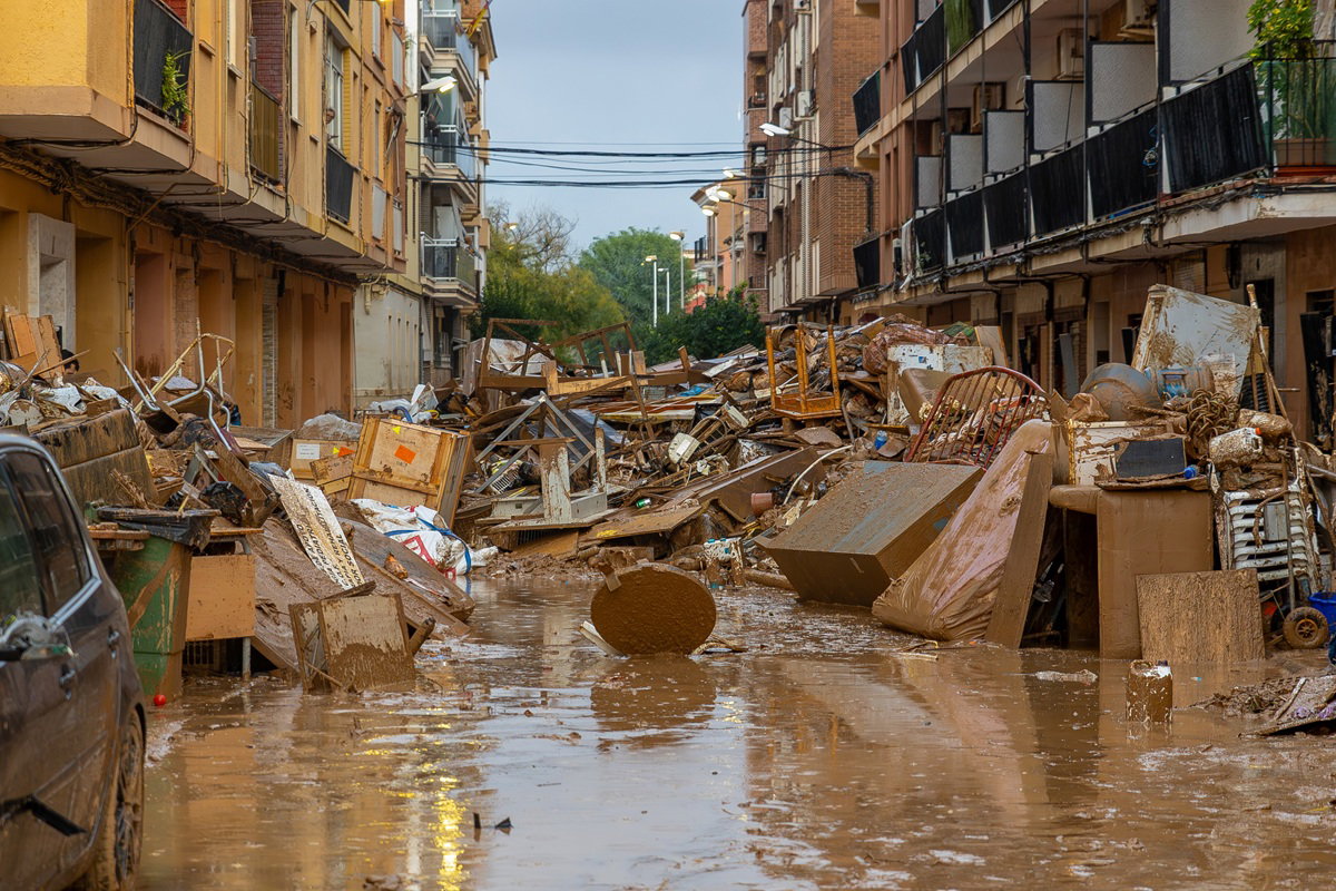
The devastating 2024 DANA floods prompted a major review of Valencia’s flood-risk maps.
Credit : David Raw, Shutterstock
Thousands of people living in flood-prone areas of Valencia could face changes to future building rules after a major review identified 61 per cent more land at risk of flooding than previously mapped.
The findings come nearly two years after the devastating DANA floods of October 2024 and could change where and how new homes are built, including restrictions on underground car parks.
The Valencian government reported the findings on Thursday, October 15, in the context of its PATRICOVA review. This is a territorial plan to mitigate and prevent flood risks in the Valencian Community.
According to the new findings by Europa Press, the mapped area at risk of flooding has increased from 27,162 hectares to 43,779 hectares, a 61.2 per cent increase.
The numbers do not mean that the probability of flooding has increased 61 per cent since 2024. The revised studies identify a much larger area that could be affected by extreme flooding than previous maps indicated.
The proposed changes are particularly important for residents, potential homebuyers and developers in the regions worst hit by the 2024 disaster.
Which areas of Valencia are now classified as being at greater flood risk?
The first phase of the review is based on four areas affected by the flooding of 29 October 2024. These are: Upper Magro, Lower Magro and the ravines of l’Horta Sud and the lower Turia below the Loriguilla dam.
Detailed assessments cover 51 municipalities, while a broader group of 85 municipalities has undergone some form of analysis.
The greatest change has been observed in the L’Horta Sud district, which has seen a greater increase in the area deemed to be flood-prone.
In the previous maps, there was an estimated 7,301 hectares at different flood risk levels. The new analysis increased this to 16,478 hectare a 125.7 per cent increase. The area of Lower Turia has increased dramatically, from 7,621 hectares to 13,903 hectare.
The changes in the Upper and Lower Magro districts are smaller, between nine per cent and ten per cent.
The differences in this data illustrate why the headline number of 61 per cent should not be applied equally to all municipalities or properties.
The review is based on extensive rainfall and hydrological data, with over 11,700 measurements from 1,090 rain gauges. Researchers have also included extreme flood events, including events with estimated return periods of up to 2,000 years.
Such a return period is a statistical measure of how rare an event is regarded. It does not mean that a similar flood can only occur once in 2,000 years.
The new maps show seven levels of flood risk, which consider the 25, 100, 500 and 2,000 year return periods. The goal of the exercise is to help government agencies prepare for events that may be rare but can have devastating consequences.
Could new homes and underground car parks face restrictions?
One of the most important implications of the review is the future construction in flood-prone areas. The proposed measures include banning new underground car parks in areas classified as having a moderate flood hazard, alongside stricter building restrictions in the most exposed locations.
In the most exposed areas, new construction could be prohibited altogether.
Other plans involve raising new buildings above the anticipated floodwater level, depending on the hazard identified in the area. The policy is designed to lower the risk for residents and to ensure that new developments do not increase the risk of flooding.The proposals also include green infrastructure and designated areas where floodwater can be temporarily stored to help reduce the impact of extreme rainfall.
However, there is an important distinction for existing homeowners. The proposals do not mean that existing underground garages across Valencia must close or that homeowners will automatically be required to rebuild properties located in newly identified flood-risk zones.
The main focus of the review is on flood risk planning and the conditions that might apply to future development.
The eventual impact of this on any specific property will be determined by the final approved plan, the location of the property and planning regulations.
The new restrictions are not yet approved. The regional government has announced that the first-stage review will be published in the Official Gazette of the Valencian Community on Friday, October 16.
A public consultation period of 20 working days is expected to follow the official publication, allowing residents and other interested parties to examine the proposals before final approval.
What should homeowners and property buyers in Valencia do?
For anyone who owns a property in the affected municipalities, the new flood maps could be a vital resource for any renovations, expansions, or future developments.
Prospective buyers might also want to find out whether a property is in a newly designated flood zone before buying it. But the new numbers cannot be used to assess the risk of a single home or whether a certain building will be allowed.
These questions should be answered by a review of the flood risk maps and city planning for the property’s precise location.
Residents can consult the official Valencian government’s mapping portal to explore existing flood-risk information. However, they should check whether the newly proposed PATRICOVA maps have been incorporated before relying on the information for property or planning decisions.
Residents should follow the release of the revised PATRICOVA documents and should contact their local council if they have any questions about planning restrictions on their land.
The Generalitat has suggested that the methodology developed for this first phase will be applied in the future to the whole of the Valencian Community.
Therefore, the current data should not be seen as a full reevaluation of the flood risk in Valencia, Alicante and Castellón provinces. The results also emphasize a lesson from the 2024 disaster: the flood maps did not fully anticipate the flooding that happened.
The region’s plan includes more extreme scenarios to offer local authorities a clearer picture for making future development and safety decisions.
The key takeaway for homeowners and homebuyers is that more land is now deemed to be flood-prone. The practical implications of this change will become more clear as the new planning regulations go through consultation and approval.







The €4,000 cost of getting around Spain is putting jobs out of reach
Eurostar disruption after crash leaves 19 injured, including five in critical condition
New Valencia flood maps reveal 61% more land at risk: Is your home affected?


-

 Uncategorized2 weeks ago
F1 Bahrain Grand Prix will be live and FREE on TV this weekend
-
Blackout preparedness2 weeks ago
Brussels takes action against Spain over failure to update blackout plan
-
 Foreign demand3 weeks ago
Market Snapshot: German Market In Q2 2026
-

 Uncategorized2 weeks ago
Lewis Hamilton F1 wish could come true as stunning plans for new track revealed
-
Latest2 weeks ago
Spain’s Government Dealt Huge Blow As MPs Reject Housing Crisis Laws
-

 Housing access / crisis / affordability2 weeks ago
Radical Housing Decrees Defeated As Snap Election Talk Grows
-
EU2 weeks ago
EU nicotine crackdown sparks warning that ex-smokers could be driven back to cigarettes
-

 General Election2 weeks ago
Political Round-Up: 87-Year-Old Maricarmen Wins Her Home Back As PM Sanchez Suffers Crucial Congress Defeat – With Snap Election Looming